We have been notified of a scam email circulating that is requesting deposits for Eagar Days vendor spaces.
⚠️ Please do NOT send money or provide information to anyone claiming to collect deposits through email messages like this.
At this time, official information for Food and Craft Vendors will only come from the Town of Eagar through the following sources:
✔️ Official Website: https://eagaraz.gov
✔️ Official Email Contact: j.vaughan@eagaraz.gov
If you receive a suspicious message regarding Eagar Days vendor deposits, please do not respond and report it to us.
We appreciate your help in keeping our vendor community safe and informed. Please share this post so others are aware.
#EagarDays #ScamAlert #VendorNotice #TownOfEagar
There is currently no water service on Burk St. & Dale St. between 9th St. and 12th St. due to ongoing work.
💧 Crews are on site and actively working to restore service as quickly as possible.
We will provide an update as soon as the water is back on. Thank you for your patience!

🌟 **Now Accepting Nominations for the 2026 Grand Marshal!** 🇺🇸
The Towns of **Eagar and Springerville** are now accepting nominations for the **2026 Fourth of July Parade Grand Marshal**!
Do you know someone who has made a lasting impact on our community? This is your chance to recognize an individual who exemplifies dedication, service, and pride in Round Valley. The selected Grand Marshal will be honored during the **2026 Fourth of July Parade**, a cherished local tradition celebrating Independence Day.
🎖 **Nominate someone today:**
https://forms.office.com/Pages/ResponsePage.aspx?id=Qztww9_YW0m9xoBP-9LvxB-rfPd0Kq1DmbkVbRoiPJ1UMEYxTk9ERENESDZQRFU0NlE4QkFQMFZLMS4u
Help us celebrate the people who make our community special! ❤️🤍💙
#RoundValley #EagarAZ #SpringervilleAZ #FourthOfJuly #CommunityPride

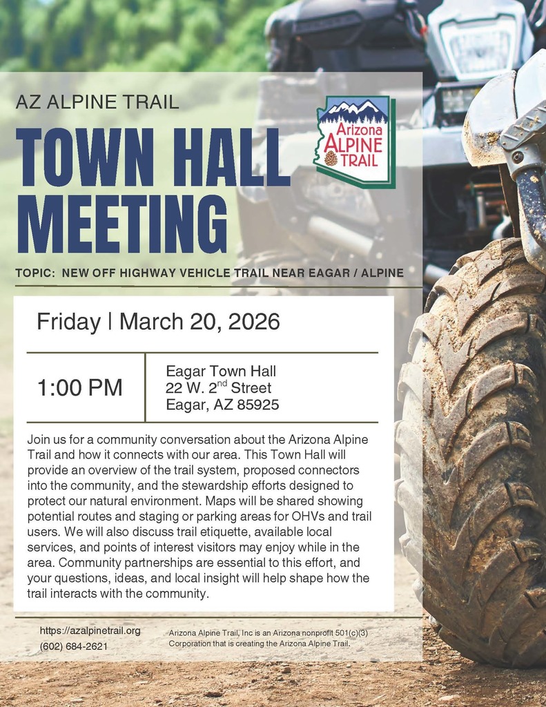
Join us for a community discussion about the proposed new Off-Highway Vehicle (OHV) trail near Eagar and Alpine and how it could connect with our area.
🗓 Friday, March 20, 2026
⏰ 1:00 PM
📍 Eagar Town Hall – 22 W. 2nd St.
Learn about potential routes, staging areas, and how this project may impact our community.
More info: https://azalpintrail.org
Volunteers Needed for the AZ 250 Traveling Museum Event!
We’re looking for community volunteers to help make the AZ 250 Traveling Museum Event a success! This exciting event celebrates Arizona’s rich history and the upcoming America 250 commemoration.
Volunteers can assist with:
• Greeting visitors
• Helping with exhibits and activities
• Supporting vendors and event staff
• General event assistance throughout the day
Your help will make a big difference in creating a memorable experience for our community and visitors. 🙌
👉 Sign up to volunteer here:
https://volunteersignup.org/XW4TX
Spots are limited, so please sign up soon! Thank you for supporting this special community event. 🇺🇸✨
Join us March 25, 2026, at Ramsey Park for this exciting stop on Arizona’s journey to America’s 250th birthday!
⭐ Opening Ceremony: 9:45 AM
⭐ Traveling Museum: Open 10:00 AM – 6:00 PM
Bring the family and explore American history through this interactive traveling exhibit. Enjoy food vendors, drink vendors, and information about the Round Valley Time Capsule project.
📍 Ramsey Park – 246 E 2nd Ave, Eagar, AZ
Questions?
📞 Jessica Vaughan: 928-333-4128
📧 j.vaughan@eagaraz.gov
Come celebrate history with us as we look ahead to America 250!
#America250 #AZ250 #TravelingMuseum #TownofEagar


The America 250 Traveling Museum is coming to Ramsey Park (2nd Ave) on March 25, 2026 from 10AM–6PM — and we’re looking for 3 food vendors and 2 drink vendors to join us!
Spots are limited, so don’t wait!
📞 Call Jessica Vaughan to register: 928-333-4128
📧 j.vaughan@eagaraz.gov
Be part of this exciting America 250 celebration in Eagar! ⭐


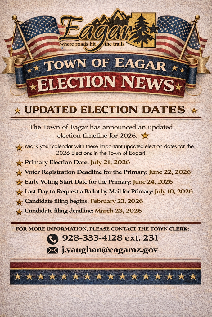
Important election dates for the 2026 Town of Eagar Primary have been updated. Make sure you’re informed and ready to participate!
🗓️ Primary Election: July 21, 2026
📝 Voter Registration Deadline: June 22, 2026
🗳️ Early Voting Begins: June 24, 2026
Additional dates for mail-in ballots and candidate filing are included on the flyer below.
For questions or more information, contact the Town Clerk at 928-333-4128 ext. 231 or j.vaughan@eagaraz.gov
#TownofEagar #Elections #RoundValley